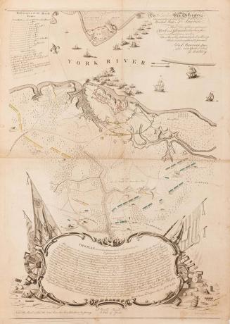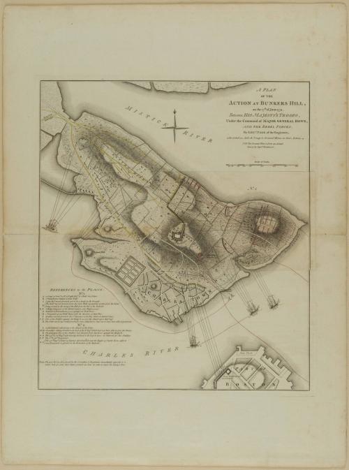
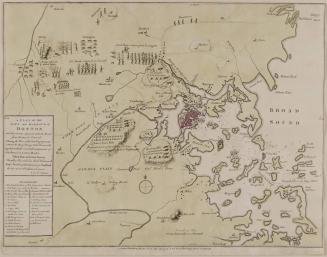
A PLAN/ OF THE/ ACTION AT BUNKERS HILL,/ on the 17th. Of June 1775./ Between HIS MAJESTY'S TROOPS,/ Under the Command of MAJOR GENERAL HOWE,/ AND THE REBEL FORCES.
Date1775-1778
Cartographer
Lieutenant Thomas Hyde Page
(1746 - 1821)
After work by
Captain John Montresor (1736-1799)
Publisher
William Faden (1750-1836)
OriginEngland, London
MediumLine engraving on laid paper with hand color
DimensionsOverall: 20 × 17 5/8in. (50.8 × 44.8cm)
Framed: 33 1/2 × 26 1/4 × 1 1/8in.
Credit LineMuseum Purchase
Object number1989-36
DescriptionThe text in the upper right reads: "A PLAN/ OF THE/ ACTION AT BUNKERS HILL,/ on the 17th. Of June 1775./ Between HIS MAJESTY'S TROOPS,/ Under the Command of MAJOR GENERAL HOWE,/ AND THE REBEL FORCES./ By LIEU.T PAGE of the Engineers,/ who acted as Aide de Camp to General Howe in that Action./ N.B. The Ground Plan is from an Actual/ Survey by Capt.n Montresor."Label TextAfter the skirmishes at Lexington and Concord, both sides realized that future conflicts were inevitable. Patriot troops positioned themselves in an arc around Boston, thereby confining the British forces to the city. On the evening of June 16, 1775, the provincial army moved under cover of darkness to Charlestown Heights and constructed earthworks on Breed’s Hill. At dawn on June 17, the British sloop Lively spotted the patriot position and opened fire. The first two attacks by the Redcoats were met with concentrated musket fire from the Americans that decimated their front lines. Their third attempt was more successful. Suffering from a shortage of ammunition, the Americans could not stop the British from penetrating the redoubt and were forced to retreat to nearby Bunker Hill. A Plan of the Action at Bunkers Hill is the most detailed contemporary representation of the battle.


November 1776