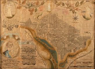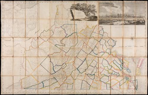
A Map of Virginia formed from actual surveys, and the latest as well as the most accurate observations
Date1807
Maker
Bishop James Madison (1749-1812)
Maker
Frederick Bossler
Maker
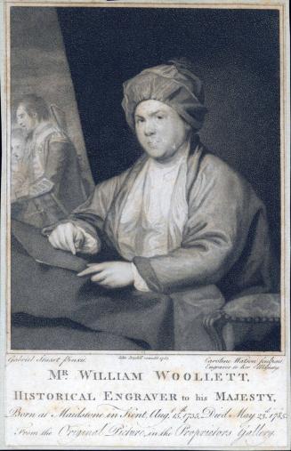
William Prentis
(1699 - 1765)
MediumBlack and white line engraving on period textile substrate; with marble paper case.
DimensionsOH: 46" x OW: 70 1/4"
Credit LineGift of William C. Wooldridge
Object number2017-284,A&B
DescriptionThe upper center cartouche reads: "A MAP OF/ Virginia/ Formed from Actual Surveys, and the/ Latest as well as most accurate observations,/ BY JAMES MADISON, D. D./ President of W.m & Mary College."The text in the left center reads: "To/ THE GENERAL ASSEMBLY OF/ VIRGINIA/ This Map is Respectfully Inscribed by their Fellow Citizens./ James Madison./ William Prentis./ William Davis./ Proprietors."
Below is an explanation of symbols: "State Line,/ County Line, / Stage Road./ Public Road,/ Stream that sinks./ Principal Town./ County Town, / Small Town or Village./ Court House./Dwelling House. Dwelling House./ House of Entertainment./ Iron Works./ Mill."
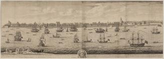
In the upper right corner is a view of "The City of/ RICHMOND Metropolis of VIRGINIA." Below are a compass rose and a scale of miles; below these elements is text that reads: "Copy Right Secured./ Richmond Published 4.th March 1807./ By the Proprietors."
Label TextBishop James Madison's "Map of Virginia Formed from Actual Survey was the first map of Virginia produced in the Commonwealth and the first comprehensive road map for the state.
Madison, first cousin of President James Madison, graduated from the College of William and Mary in 1771, studied law under George Wythe, and later was ordained in the Church of England. In 1777, Madison became president of the college, a position he held for thirty-five years. By the terms of the 1693 charter of the college, the trustees were given the responsibility of designating the surveyor general of Virginia. That duty shifted to the governor in 1779, although the surveyor general was "to be nominated, examined, and certified able by the president and professors of William and Mary college, and if of good character, commissioned by the governour." [1]
Madison's official role as president of William and Mary in selecting the surveyor general undoubtedly interested him. In 1779, he served on the commission that defined the boundary between Virginia and Pennsylvania. Madison's curiosity about the natural world was of long standing. He had been elected professor of natural philosophy and mathematics at the college in 1773. He corresponded with Jefferson on topics such as climate, astronomy, marine life, skin pigmentation, and geography.
Aware of the need for a new scientific map of Virginia, Madison assumed the task of gathering data for the project. His goal was to improve earlier observations of latitude and longitude, to ensure the correctness of newly formed county boundaries, to gather the most up-to-date information on the courses of rivers and bearings on mountains from regional surveys, and to depict the state's boundaries accurately.2 He sought the assistance of William Prentis of Petersburg to assemble and compile the information. Prentis's initial manuscript was passed to William Davis, who Madison described as "a neat, correct and intelligent draughtsman," so it could be rendered in a form from which the engraver, Frederick Bossler, could produce plates.[3]
Madison did not receive financial assistance from the Virginia Assembly as he may have hoped:
"The proprietors finding that most of the other states had recently given encouragement to similar productions and entertaining a high sense of the real dignity and importance of Virginia, embarked in the business, from a well-grounded belief that the magnitude and utility of the work, would insure, if accomplished, a remuneration."[4]
As John Henry had done almost four decades earlier, Madison decided to finance the project through subscription. The cost was to be eight dollars, one to be paid upon subscribing. The price for non-subscribers would be two dollars.
The map, which included extensive topographical features that reflected Madison's interest in natural history, was published on March 4, 1807. (This copy) The depiction of new roads provided a wealth of detail for travelers and the work became known as the first true road map of Virginia. Numerous errors caused Davis to revise it and a second state was published in 1818, six years after Madison's death. The result was a virtually new map. For instance, more than forty new counties were added to the Ohio inset alone. Even the boundaries of some long-established counties such as Princess Anne were altered.
One of the most striking features is the view of Richmond in the upper right corner. The design, executed around 1805, was taken from a drawing by Charles-Balthazar-Julien Févret de Saint-Mémin. Given Madison's friendship with Jefferson, it is understandable that the state capitol was chosen to embellish the map since Jefferson was responsible for the design of the building. Saint-Mémin's drawing also reflected something of the character of the state. He juxtaposed the tranquil rural terrain with the James River in the foreground against the flourishing city of Richmond, which was described on the map as the Metropolis of Virginia.
1. William Waller Hening, ed., The Statutes at Large; Being a Collection of All the Laws of Virginia, from the First Session of the Legislature in the Year 1619 (New York, Philadelphia, and Richmond, Va., 1819-1823), X, p. 53.
2. Ibid., XI, p. 352.
3. Bishop James Madison to William Prentis, Feb.1, 1805, Earl G. Swem, comp., Maps Relating to Virginia in the Virginia State Library and other Departments of the Commonwealth (Richmond, Va., 1914), p. 85.
4. Ibid.
5. Richmond Enquirer (Va.), Feb. 15, 1805, ibid.