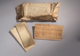
Pincushion, Map of North America
Date1800-1820
Possibly Retailed by
William Darton Jr.
OriginEngland, London
MediumSilk, ink, watercolor, and metal
DimensionsOverall: 2" (5.1cm)
Credit LineMuseum Purchase
Object number2019-115
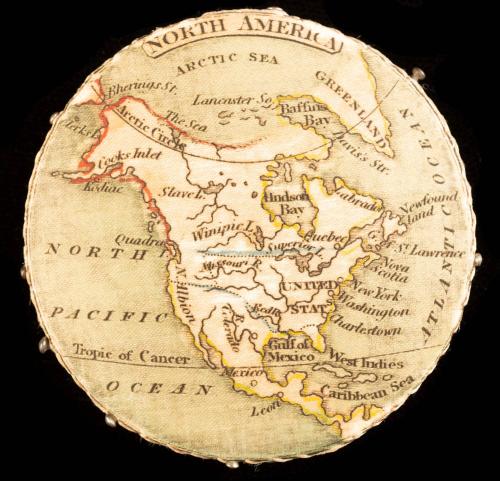
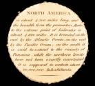
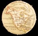
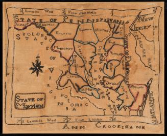
DescriptionThis is a silk medallion pincushion printed with a map of North America on the obverse and a geographical description on the reverse. The borders and place names are printed in black ink while the ocean and borders are colored with blue, yellow, and red watercolor. They read: "NORTH AMERICA/ ARCTIC SEA/ GREENLAND/ Bherings [sic] St./ Lancaster So./ Baffins [sic]/ Bay/ Davis’s Str./ The Sea/ Arctic Circle/ [?]rks L / Cooks Inlet / Kodiac [sic] / Slave L. / Hndson [sic]/Bay/ Labrador/ Newfound/land / Winipic [sic] L / Superior L. / Quebec/ G. of St. Lawrence / Quadra / Superior L. / Nova Scotia / NORTH/PACIFIC/OCEAN / Missouri R. / N. Albion / UNITED/STATS [sic] / New York / Washington / R. Colorado / Red R / Charleston / GULF of/ MEXICO / West Indies / Tropic of Cancer / Mexico / Caribbean Sea / Leon / ATLANTIC OCEAN"The geographical description reads: "NORTH AMERICA is about 4,500 miles long, and the breadth from the promontory Alaska to the extreme point of Labrador is about 4,600 miles. It is bounded on the east by the Atlantic Ocean; on the west by the Pacific Ocean; on the south it is said to extend to the vicinity of Panama, while the northern limits have not been exactly assertained [sic] it is supposed to contain about 20,000,000 Inhabitants."
Eight metal pins are inserted along the side.
Label TextDuring the late eighteenth and early nineteenth centuries, geography became a core feature of children’s school curriculums. In response to this burgeoning interest, publishers began to manufacture a wide range of geographical toys, including dissected maps, board games, and tabletop dioramas. As an educational tool, this pincushion combined the emerging interest in geography with the long-standing practice of needlework instruction.
The London publisher Robert Miller produced the earliest known version of a silk medallion pincushion with cartographic imagery; this pincushion displayed a map of England and Wales on one side and a map of Ireland on the other. In 1819, William Darton, Jr. acquired Miller’s stock and potentially used the latter’s copperplates to produce his own silk medallion pincushions.
The plates used to produce silk medallion pincushions were also used to create decorative inserts for watches called “watch-papers.” Although they are typically called “watch-papers,” these inserts could be made from linen and silk as well as paper. Publishers frequently sold both watch-papers and silk medallion pincushions using the same designs.
It is possible that this pincushion was sold by Robert Darton, Jr. Unlike the silk medallion pincushions produced by Robert Miller, this example is slightly larger, bears no imprint, and has descriptive text on the reverse. Although there is no written record that indicates that William Darton, Jr. produced silk medallion pincushions, it is known that he sold a number of watch-papers, some of which were decorated with maps.
The descriptive text included on the reverse of this pincushion was likely compiled from a variety of sources. The language that describes the breadth of the continent can be found verbatim in John Pinkerton’s Modern Geography, Benjamin Davies’s A New System of Modern Geography, and Thomas Ewing’s A System of Geography.
Inscribed"NORTH AMERICA/ ARCTIC SEA/ GREENLAND/ Bherings [sic] St./ Lancaster So./ Baffins [sic]/ Bay/ Davis’s Str./ The Sea/ Arctic Circle/ [?]rks L / Cooks Inlet / Kodiac [sic] / Slave L. / Hndson [sic]/Bay/ Labrador/ Newfound/land / Winipic [sic] L / Superior L. / Quebec/ G. of St. Lawrence / Quadra / Superior L. / Nova Scotia / NORTH/PACIFIC/OCEAN / Missouri R. / N. Albion / UNITED/STATS [sic] / New York / Washington / R. Colorado / Red R / Charleston / GULF of/ MEXICO / West Indies / Tropic of Cancer / Mexico / Caribbean Sea / Leon / ATLANTIC OCEAN"
"NORTH AMERICA is about 4,500 miles long, and the breadth from the promontory Alaska to the extreme point of Labrador is about 4,600 miles. It is bounded on the east by the Atlantic Ocean; on the west by the Pacific Ocean; on the south it is said to extend to the vicinity of Panama, while the northern limits have not been exactly assertained [sic] it is supposed to contain about 20,000,000 Inhabitants."

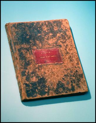
1824-1828 (range of the entires in the album).

ca. 1770