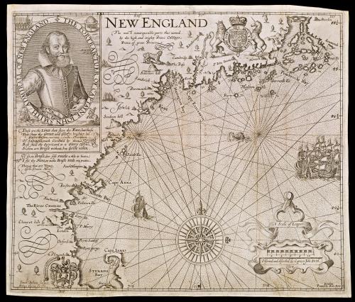
NEW ENGLAND
Date1624; originally published in 1616
Cartographer
Captain John Smith (1580-1631)
Engraver
Simon van de Pass (1595-1647)
Publisher
George Low
Publisher
Robert Clerke
OriginEngland, London
MediumLine engraving on laid paper
DimensionsOverall: 11 7/8 × 14 1/16in. (30.2 × 35.7cm)
Framed: 19 3/4 × 20 7/8 × 5/8in.
Credit LineMuseum Purchase
Object number1972-37
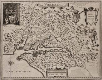
DescriptionIn the upper left corner, an engraved portrait of Smith is seen surrounded by an oval with the words: "THE PORTRAICTUER OF CAPTAYNE IOHN SMITH / ADMIRALL OF NEW ENGLAND." Text within the portrait reads: "Ætat 37./ A.o 1616"
A poem below the portrait reads: "These are the Lines that shew thy Face; but those/ That shew thy Grace and Glory, brighter bee:/ Thy Faire-Discoveries and Fowle-Overthrowes/ Of Salvages, much Civilliz'd by thee/ Best shew thy Spirit; and to it Glory Wyn:/ So, thou art Brasse without, but Golde within./ If so; in Brasse, (too soft Smiths Acts to beare)/ I fix thy Fame, to make Brasse Steele out weare./ Thine, as thou art Virtues,/ John Davies. Heref:"
The text between the portrait and King James I's coat of arms reads: "NEW ENGLAND/ The most remarqueable parts thus named./ by the high and mighty Prince CHARLES,/ Prince of great Britaine"
The text attached to the scale of distances reads: "A Scale of Leagues/ Observed and described by Captayn John Smith./ 1614"
The lower left margin reads: "Simon Passeus Sculpsis./ Robert Clerke [?]
The lower right margin reads: "London/ Printed by Geor: Low"
Label TextThe nomenclature and the decoration of the New England map reveal a different attitude towards America than that conveyed in the Virginia image. In the brief seven-year period between the time Smith explored Virginia and charted the New England coast, England's interest had shifted from one of discovery and exploration to establishing settlements and claiming land. Unlike the Virginia map, where Smith meticulously identified Indian villages, there are no Native American sites shown on the New England map. All of the Native American villages were replaced by recognizable English names.
On March 3, 1614, Captain John Smith set sail for North America, this time for New England. Two vessels and a crew of forty-five, under the command of Smith, were sent for the specific purpose of whaling, and mining gold and copper. Should either of these ventures prove unsuccessful, they were charged with finding another way to at least cover their expenses, perhaps by bartering for furs and fish. The whales off the coast of Maine, where Smith and his crew landed, were too large and fast for their vessels, and Smith had already experienced the difficulties of mining for minerals in Virginia. Therefore, he left behind a large portion of his crew to fish in local waters while he traveled southward to trade for furs and explore the New England coast. Smith returned to England after spending only about six weeks exploring the New England coastline. While his cargo was not adequate enought to cover the expenses of the trip, he returend with valuable geographic information and great enthusiasm for establishing a colony at Plymouth. By the summer of 1615 Smith had raised enough support in England to fund two vessels for his venture. From the time of his departure, however, Smith and his crew wer plagues with difficulties. After several small encounters with pirate ships, Smith was eventually captured by a French "man-of-war." While he was held captive, Smith took the opportunity to writ of his experiences over the past several years that would later be published as A Description of New England. The accompanying map, illustrating the New England coastline from Penobscot Bay southward to Cape Cod, was based on Smith's explorations during the expedition of 1612. Although Smith himself never returned to America, his map of New England proved to be a valuable resource for subsequent expeditions. As Smith notes on the map, "The most remarkable parts thus named by the high and mighty Prince Charles nowe King of great Britaine." Very few of those names survive today other than Plymouth (Plimouth), Cape Ann (Cape Anna), and The River Charles (Charles River).
1760 (dated)
ca. 1825
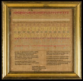
1786 (dated)
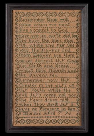
April 1796 (dated)

ca. 1790