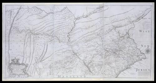
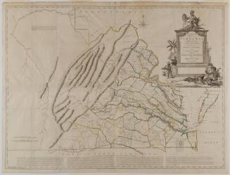
To the Honourable/ Thomas Penn and Richard Penn Esq.rs/ True & absolute Proprietaries & Governours of the Province of/ Pennsylvania & Counties of New-Castle Kent & Sussex on Delaware/ THIS MAP/ Of the improved Part of the Province of/ PENNSYLVANIA.
Date1759
Cartographer
Nicholas Scull (1687-1762)
Engraver
James Turner (1722-1759)
Printer
John D. Davis
MediumLine engraving on laid paper
DimensionsOverall: 30 5/8 × 21in. (77.8 × 53.3cm)
Framed: 36 3/4 × 67 1/8 × 1 7/8in.
Credit LineGift funds from The Acorn Foundation, Mrs. Anna Glen B. Vietor in memory of her husband
Object number1985-73,A-C
DescriptionThe lower left cartouche reads: "To the Honourable/ Thomas Penn and Richard Penn Esq.rs/ True & absolute Proprietaries & Governours of the Province of/ Pennsylvania & Counties of New-Castle Kent & Sussex on Delaware/ THIS MAP/ Of the improved Part of the Province of/ PENNSYLVANIA./ Is humbly dedicated by/ Nicholas Scull"The text in the lower center above "MARYLAND" reads: "PHILADELPHIA. Engraved by Ja.s Turner, and Printed by John Davis for the Author."
The text in the lower right reads: "Published according to Act of Parliament Jan. 1.st 1759. & Sold by the Author, Nicholas Scull in Second-Street PHILADELPHIA."
Label TextNicholas Scull's Map of the improved Part of the Province of Pennsylvania was the first large-scale map of Pennsylvania and the first devoted solely to that colony printed in America. As the title suggests, Scull concentrated on the "improved" or settled parts of the province. The far northern and western areas of the present state of Pennsylvania including Pittsburgh, were omitted. The map featured details never before rendered on a map of Pennsylvania. Forts, iron forges, mills, meetinghouses, inns, Indian towns, and gentlemen's seats were all depicted. The roads and Indian paths were of particular importance.


April 1, 1773
