The History of the Rise, Progress, and Establishment, of the Independence of the United States of America: Including an Account of the Late War; and of the Thirteen Colonies, from their Origin to that Period
Date1788
Maker
William Gordon
(1728 - 1807)
OriginEngland, London
MediumBoards covered in marle paper with leather corners and spine decorated with gold gilt decoration.
DimensionsA: OH: 8 5/8" x OW: 5 5/8" x OD: 1 1/2"
B: OH: 8 3/4" x OW: 5 3/4" x OD: 1 3/4"
C: OH: 8 3/4" x OW: 5 5/8" x OD: 1 1/2"
D: OH: 8 3/4" x OW: 5 5/8" x OD: 1 1/2"
Credit LineMuseum Purchase
Object number2017-145,1-4
DescriptionFour volumes; Title page of Volume I reads: "THE/ HISTORY/ RISE, PROGRESS, AND ESTABLISHMENT,/ OF THE/ INDEPENDENCE/ OF THE/ UNITED STATES OF AMERICA:/ INCLUDING/ AN ACCOUNT OF THE LATE WAR;/ AND OF THE/ THIRTEEN COLONIES,/ FROM THEIR ORIGIN IN THAT PERIOD./ BY WILLIAM GORDON, D.D./ QUID VERUM *** CURO, ET ROGO, ET OMNIS IN HOC SUM./ HORAT. 1 Ep. 1 Lib./ IN FOUR VOLUMES./ VOL I./ LONDON:/ PRINTED FOR THE AUTHOR;/ AND SOLD BY CHARLES DILLY, IN THE POULTRY; AND/ JAMES BUCKLAND, IN PATER-NOSTER-ROW./ M DCC LXXXVIII./ [Entered at Stationers=Ball.]Label TextPublished in 1788 by William Gordon, this work in four volumes comprises the history of the thirteen colonies and the American Revolution. The volumes contain ten maps illustrating various parts of the eastern United States, as well as some campaigns. According to bibliographer Joseph Sabin, "Gordon is deservedly reckoned as the most impartial and reliable of the numerous historians of the American Revolution."
Contains the following maps:
Vol 1
"The/ UNITED STATES/ of/ AMERICA."
Vol 2
"BOSTON,/ with its Environs."
"NEW YORK/ ISLAND,/ & parts adjacent."
"THE JERSEYS,/ &c. &c."
"NEW HAMPSHIRE, VERMONT, &c."
Vol 3
"THE CAROLINA'S,/ with part of/ GEORGIA."
[2 maps on same pullout leaf]: "A Sketch of/ the Operations before/ CHARLESTOWN,/ SOUTH CAROLINA./ 1780." and "A Sketch/ of Sr. Peter Parker's/ Attack on/ FORT MOULTRIE,/ June 28th/ 1776."
Vol 4
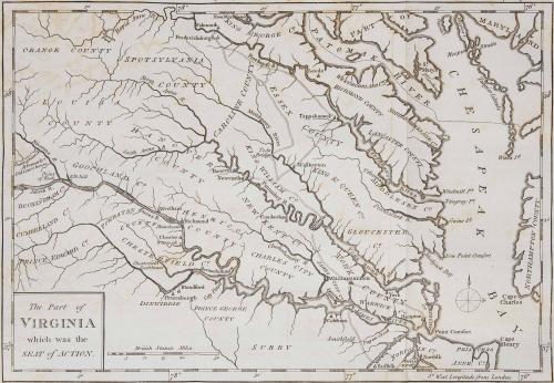
"The Part of/ VIRGINIA/ which was the/ SEAT of ACTION."
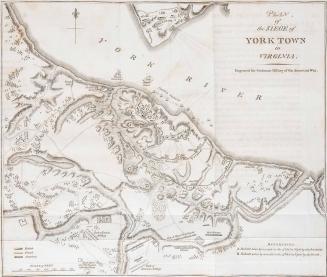
"YORK TOWN,/ and/ GLOUCESTER POINT./ as beseiged by/ The ALLIED ARMY."
This copy of "The Part of/ VIRGINIA/ which was the/ SEAT of ACTION" (#150) and "YORK TOWN,/ and/ GLOUCESTER POINT./ as beseiged by/ The ALLIED ARMY" (#162) was published in William C. Wooldridge, "Mapping Virginia: From the Age of Exploration to the Civil War" (Charlottesville: University of Virginia Press, 2012), p.164; p. 179.


1660-1729

ca. 1740