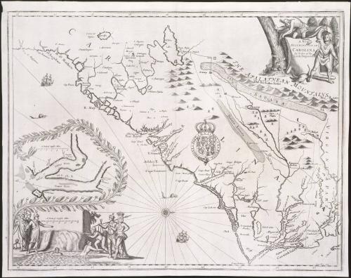
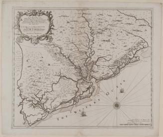
A New/ DISCRIPTION OF/ CAROLINA/ By Order of the/ Lords Proprietors
Date1672
Cartographer
John Ogilby (1600-1676)
Engraver
James Moxon (fl. 1647-1696)
Publisher
John Ogilby (1600-1676)
OriginEngland, London
MediumLine engraving on laid paper
DimensionsOverall: 16 1/2 × 21 1/2in. (41.9 × 54.6cm)
Framed: 25 1/4 × 29 1/4 × 7/8in.
Credit LineMuseum Purchase
Object number1989-317
DescriptionThe upper right cartouche reads: "A New/ DISCRIPTION OF/ CAROLINA/ By Order of the/ Lords Proprietors"The lower right corner reads: "James Moxon Scul."
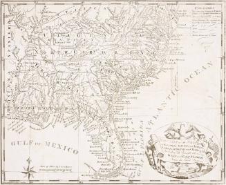
Label TextCarolina was established in 1663 when Charles II granted the province to eight favorites, known as the Lords Proprietors, who had helped him regain the throne of England. The original grant included the territory between the 31º to the 36 1/2º north latitude, from Jekyll Island, Georgia, to Currituck Inlet, North Carolina. Two years later, the tract was enlarged to include the land between 29º north and 31º latitude, thus adding a large portion of Florida. The grant extended west to the Pacific Ocean.
The Lords Proprietors wanted to attract potential settlers to the area. Just as John Ogilby's map of Maryland was a promotional piece for Lord Baltimore, A New Discription of Carolina was intended to encourage people to colonize Carolina. Recently established counties in the Carolinas appeared for the first time on Ogilby's map.
John Ogilby advertised in the London Gazette in October 1671 that "his second Book of the English Atlas (being America) will be Publisht on Wednesday the 3 of November."1 In gathering information on Carolina, Ogilby turned to philosopher John Locke, who wrote the "Fundamental Constitutions" for the province. Locke was secretary to Lord Ashley, Earl of Shaftesbury, one of the most influential of the Lords Proprietors. Ogilby's text, taken largely from Locke's information, described Carolina's climate, natural resources, and inhabitants. Ogilby praised the friendliness of the natives and their good relationship with the colonists in great detail. On the map, Englishmen and Indians have gathered congenially in the lower left corner.
For the geography Ogilby relied heavily on the explorations of John Lederer, a German interested in trade with the Indians, who made three expeditions southwest of Virginia and Carolina in 1669-1670 to locate a route through the Appalachian Mountains. Lederer's explorations ultimately helped open the great Indian path to the Southwest. Accompanied by a printed map illustrating the journeys, his account was published in London in 1672.
Some inaccurate information depicted on Lederer's map unfortunately was borrowed by subsequent mapmakers anxious for new knowledge of England's colonial holdings. Ogilby was among a number of cartographers who included Lederer's imaginary lake of Ushery (renamed Lake Ashley, after the Earl of Shaftsbury, in 1672). Historians have suggested that perhaps Lederer saw the Catawba River during a flood and mistook it for a large lake.2 Just east of the Appalachians, Lederer recorded a greatly exaggerated Savanæ [savanna] that also appeared on Ogilby's map. Lederer helped to establish a route vital to the success of the Virginia Indian trade. Although his accounts provided important information, it is regrettable that Lederer is commonly remembered for the physical distortions he imposed on the terrain.
1. Sarah Tyacke, London Map-Sellers 1660-1720: A collection of advertisements for maps placed in the London Gazette 1668-1719 with biographical notes on the map-sellers (Tring, Herts., Eng., 1978), p. 5.
2. Cumming, Southeast in Early Maps, p. 17.


1624; originally published in 1616