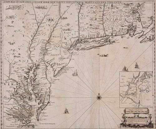
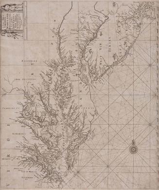
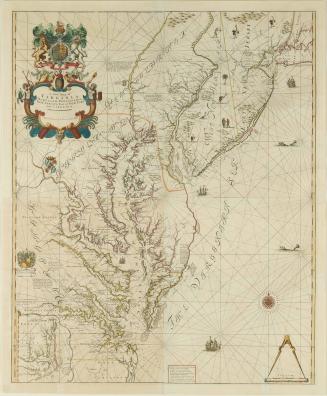
New Map of New England New York New Jarsey Pensilvania Maryland and Virginia
Date1685
Maker
Robert Morden (d. 1703)
Maker
Phillip Lea (fl. 1666-1700, d. 1700)
Maker
John Thornton
(1641 - 1708)
OriginEngland, London
MediumBlack and white line engraving with period color
DimensionsTo the neat lines: 17 3/4" x 21 3/8"
Credit LineMuseum Purchase
Object number2017-88
DescriptionUpper margin: "A NEW MAP OF NEW ENGLAND. NEW YORK. NEW IARSEY. PENSILVANIA. MARYLAND. AND VIRGINIA." Cartouche reads: "Sold by Iohn Thornton at y.e Platt in y.e Minories./ By Rob.t Morden at the Atlas in Corn-hill./ And by Phillip Lea at y.e Atlas & Herculus/ in the Poultry/ London."
Label TextIn May 1685, John Thornton, Robert Morden, and Philip Lea advertised a four-sheet "new Map of the English Empire in America viz. New England, New York, New Jersey, Pensilvania, Maryland, Virginia and Caroline" in the 'Term Catalogues.' (1) To maximize their profit, they designed it so that the upper right sheet contained the bulk of the geographical information. This section, engraved with its own, 'A New Map of New England New Jarsey Pensilvania Maryland and Virginia,' could also be marketed separately, When it was used for the wall map, the title was trimmed off or pasted over.
This is an example of the separately designed single sheet. It was based on Thornton and Green's 'A Mapp of Virginia Maryland, New Jarsey New-York, & New England but was altered to account for the establishment of Pennsylvania in 1681. Close to examination revealed that the area around New York was reengraved and that the map originally lacked the inset of New York Harbor. These alterations were taken from the ca. 1683 manuscript map made by Philip Wells for William Penn and the proprietors of East Jersey. Cohen and Augustyn described the inset as the first separate printed chart of the New York Harbor. (2)
Lea listed this map in his catalogs for 1685, 1687, and ca. 1698. State two (this copy) appears in Lea's composite atlas in the Library of Congress. State three appears in Lea's composite atlas in the Burden collection. It does not appear in the British Library copy.
1. Only one unassembled, incomplete set survives, in the Bibliothèque Nationale, Paris. McCorkle suggested that the four sheets were an unfinished proof set and were never published. 'New England in Early Printed Maps, entry 685.3. However, the consistent listing of the four-sheet map in Lea's catalogs and the 'Term Catalogues' refutes this idea. The map was based on several sources. The title sheet contained a partial depiction of the eastern Great Lakes copied from Morden and Berry's 'A Map of New England New Yorke New Jersey &c. Ibid.,' entry 676.3. The lower left sheet, which is missing, was probably based on Gascoyne's 'A New Map of the Country of Carolina, (fig. 282).
2. Cohen and Augustyn, ' Manhattan in Maps,' pp. 48-49.
This copy published in William C. Wooldridge, Mapping Virginia: From the Age of Exploration to the Civil War (Charlottesville: University of Virginia Press, 2012), #82, pp. 85-90.

1723-1728, originally published ca. 1701

After 1735; originally published 1715