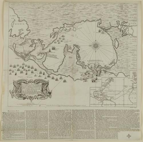
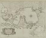
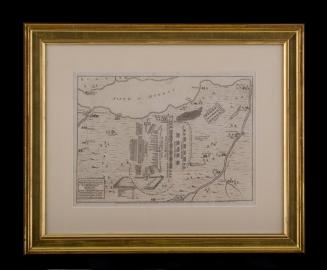
A/ New and Correct Plan of the Harbour/ of CARTHAGENA in AMERICA
Date1741
Cartographer
Pierre Chassereau
Publisher
Thomas Bowles II
(ca.1689 - 1767)
Publisher
John Bowles
(1701 - 1779)
Engraver
Richard Parr
(fl. 1723 - 1751)
OriginEngland, London
MediumLine engraving on laid paper
DimensionsOverall: 21 3/4 × 21 1/2in. (55.2 × 54.6cm)
Framed: 30 5/8 × 30 1/8 × 7/8in.
Credit LineMuseum Purchase
Object number1989-109
DescriptionThe lower left cartouche reads: "A/ New and Correct Plan of the Harbour/ of CARTHAGENA in AMERICA/ Seated 10 Degrees 26 Minutes Lat./ North and 75 Degrees 21 Long./ West of London, from a Draught/ brought to England by/ By Pet. Chassereau Archi: Also a/ View of the Fleet as they Anchor'd on y.e Coast of Playa/ Grande & as they after moved to y.e Forts S.t Iago S.t Phi:/ lip & Boccachica & after into y.e Harbour in Order to/ Beseige y.e Town agreeable to y.e Acc.t brought/ over by CAPT: LAWS."The lower margin reads: "Publish'd May 25, 1741./ Sold by Tho: Bowles in S.t Pauls Church Yard & Iohn Bowles at y.e Black Horse in Cornhill./ R. Parr Sculp"
Label TextConflicts between England and Spain occurred from the time the two nations founded settlements in the New World. English merchants anxious to profit from Spanish riches in the New World petitioned the government to take military action. As a result, Parliament instructed the Duke of Newcastle, secretary of state for the Southern Department, to send reinforcements to aid in attacks against the Spanish in the Caribbean. Troops arrived at Cartagena on March 4. From the beginning, the English commanders disagreed on military strategy. Delays in the campaign allowed the Spanish time to prepare and for the rainy, yellow fever season to set in.
ca. 1755

After 1735; originally published 1715
ca. 1760