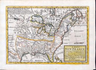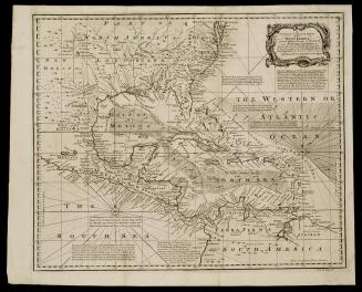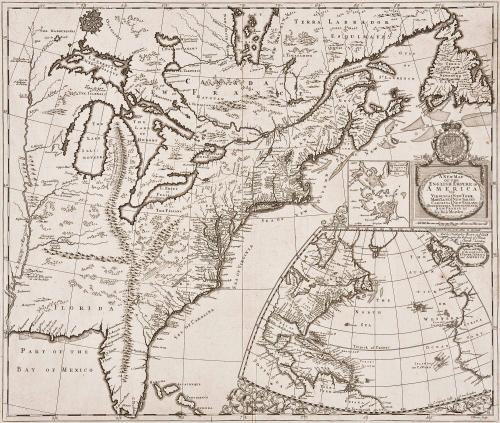
A New Map of the English Empire in America viz Virginia New York Maryland New Jarsey Carolina New England Pennsylvania Newfoundland New France &c by Rob: Morden Sold by Rob't Morden at the Atlas in Cornhill. And by Christopher Brown at ye Globe near the West end of St. Pauls Church: London
Date1695
Maker
Robert Morden (d. 1703)
OriginEngland, London
MediumBlack and white line engraving
DimensionsTo the neat lines: 19 3/4" x 23 1/8"
Credit LineMuseum Purchase
Object number2017-91
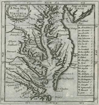
DescriptionCartouche reads: A NEW MAP/ OF THE/ ENGLISH EMPIRE/ AMERICA / VIZ/ VIRGINIA NEW YORK/ MARYLAND NEW IARSEY/ CAROLINA NEW ENGLAND/ PENNSYLVANIA NEWFOUNDLAND/ NEWFRANCE &c. / by Rob. Morden."To the left of cartouche is an inset: "the Harbour of/ BOSTON/ or Mattathusetts Bay."
A second inset in the lower right corner is "A Generall Map / of the COasts & Isles of/ EUROPE, AFRICA/ and AMERICA."
In the upper right of the second inset is the imprint "Sold by Christopher Bron at y.e Globe / near the Westend of S.t Pauls/ Church : London."
Label TextWith King William's War in mind, Robert Morden compiled this map illustrating the relative positions of the English and French territories in North America. The depictions of Canada, the Mississippi Valley, and the Great Lakes were based on important French sources, including maps by Dablon and Thevenot. (2) Morden included out-dated information on the Carolinas from "A Map of the Whole Territory Traversed by John Lederer." (2017-219)The inset map of Boston was derived from Thomas Pound's "A New Mapp of New England from Cape Codd to Cape Sables, published in 1691. (3) The coastal outline of the second inset may have been borrowed from a similar one Thornton, Morden, and Lea's "A New Map of the English Empire." (4)
1. Christopher Browne took over Robert Walton's shop, "The Globe," in 1688.
2. Claude Dablon's map, "Lac Superieur et autres Lieux ou sont Les Missons des Peres de la Compagnie de Jesus," was published in Paris in 1672. Heidenreich and Dahl, "French Mapping of North America," p. 7. For Thevenot see Custis Atlas Cat. 66, n. 3 (Margaret Beck Pritchard and Henry G. Taliaferro, "Degrees of Latitude: Mapping Colonial America" [Williamsburg, VA: Colonial Williamsburg Foundation, in association with Harry N. Abrams, 2002]).
3. McCorkle, "New England in Early Printed Maps," entry 692.3.
4. "A New Map of the English Empire was published in four sheets. For more information, see Custis Atlas Cat. 70 (Pritchard and Taliaferro, "Degrees of Latitude").
This map is published in William C. Wooldridge, "Mapping Virginia: From the Age of Exploration to the Civil War" (Charlottesville: University of Virginia Press, 2012), #91, p. 91.


After 1735; originally published 1715

1688/1693/1700