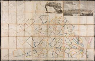
A Map of the State of Virginia
Date1827/1859
Maker
Herman Boye
Maker
Lewis von Buchholdtz
Engraver
Henry Schenck Tanner (1786-1858)
MediumLine engraving with original outline color
DimensionsIn three panels; each individual panel: OH: 61" x OW: 31"
Credit LineMuseum Purchase
Object number2017-176
DescriptionTitle reads: "A Map of the State/ of/ VIRGINIA/ Constructed, in conformity to LAW, from the late SURVEYS/ authorized by the LEGISLATURE and other ori-/ginal and authentic Documents, by Herman Boye/ 1825/ Corrected by order of the EXECUTIVE/ 1859/ by L v Buchholtz"Label TextThis very large map of Virginia is made up of nine sheets in three panels. It was commissioned by the Virginia legislature in 1816 because of the need for internal improvements, coinciding with the establishment of a Board of Public Works and a Fund for Internal Improvements. In the top left is a vignette of the University of Virginia, and in the top right is a "View of Richmond from the West."
This copy appears in William C. Wooldridge, "Mapping Virginia: From the Age of Exploration to the Civil War" (Charlottesville: University of Virginia Press, 2012), 217-219.


1733-1738