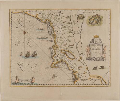
NOVA/ BELGICA/ ET/ ANGLIA/ NOVA
Date1635
Cartographer
Willem Janszoon Blaeu
(1571 - 1638)
Publisher
Willem Janszoon Blaeu
(1571 - 1638)
Publisher
Joan Blaeu
(1596 - 1673)
MediumLine engraving on laid paper with hand color
DimensionsOverall: 15 1/4 × 19 3/4in. (38.7 × 50.2cm)
Framed: 23 × 26 3/8 × 7/8in.
Credit LineMuseum Purchase
Object number1968-128
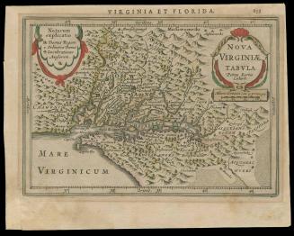
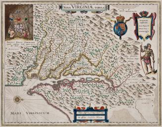
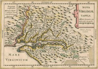
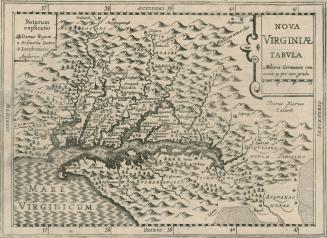
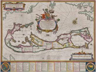
DescriptionThe right center cartouche reads: " NOVA/ BELGICA/ ET/ ANGLIA/ NOVA"Label TextAn effective complement to the Smith map that focuses on the coastline and waterways, this map by William Blaeu supplies more detail on the terrain. Blaeu's intent was to supply the East India Company with maps of the region because of its interest in the New England fur trade. The profits realized from this trade served as a primary catalyst for map production in the northern colonies.
Like many of the early maps illustrating North America, the orientation is with north to the right.
ProvenanceThere were two issues of the atlas from which this is taken. Blaeu, Willem Janszoon, LE GRAND ATLAS published in Amsterdam in 1635 and 1667. This map of New Netherlands and New England is one of two in this catalog directly relatioin to the Dutch settlement of what is today Manhattan and the Hudson river Valley. The Dutch effectively occupied this area for a period of fifty years, from 1614 until 1664, when the territory passed from Dutch to English hands. There were two distinct eras of Dutch occupation in the Hudson River Valley. The first began under the three year charter of the New Netherland Company (1614-17) followed by a six year period of open trade for independent Dutch merchants. The second era was that of the Dutch West India Company, from 1623 until 1664. although not published until 1635, this map by Willem Janszoon Blaeu relates to the first period of occupation--that of the New Netherland Company. By the latter decades of the sixteenth century, increased prosperity throughout Western Europe greatly expanded the market for importation of luxury items from foreign countries, and the Dutch were among the most active participants in this flourishing world trade. The Dutch East India Company's monopoly on trade with the Orient virtually excluded other European countries from that market. In 1609 the Dutch became aware of the English explorer Henry Hudson's discovery of the area that is known today as the Hudson River Valley. Therefore, the following year several of the Amsterdam investors in the Dutch East India Company hired Hudson to sail westward to America in search of a northwest passage to the Orient, anticipating that such a discovery would greatly enhance their trading activities. Initially, from the investor's perspective, Hudson's failure to locate a passage rendered the expedition a failure. However, with his return came reports describing the land in what we know today as the Hudson River Valley as possessing an abundance of fur-providing animals and inhabited by friendly natives. Moreover, other European powers had not yet established a monopoly on the fur trade in that area. There were significant incentives for the Dutch in establishing a foothold in what would become New Netherland, primarily that it would enable the Dutch to compete with the French, who controlled the North American fur trade along the St. Lawrence River and in Canada. After a great deal of of competition, conflict, and petitioning between certain independent Amsterdam merchants interested in establishing a trade in the area, they were finally able to unite and in 1614 the New Netherland Company was formed and given a three-year monopoly on the New England fur trade. They established their foothold up the Hudson River, erecting a fort called Fort Nassau on an island in the river near present day Albany. The Dutch named the area encompassing the Hudson River Valley, "Niev Nederlandt." The New Netherland Company controlled the Dutch fur trade in the Hudson River
First published 1606; This example: 1634
c. 1700