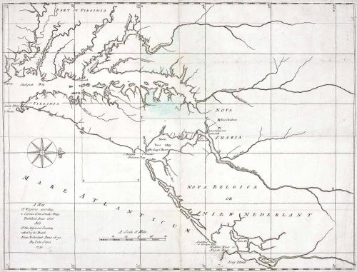
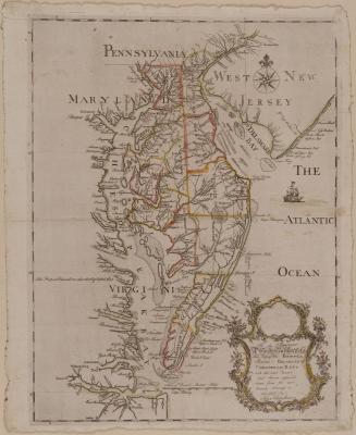
Map of Virginia according to Captain John Smith's Map Published Ano 1606 Also Of the Adjacent Country called by the Dutch Nieu Nederlant
Date1735
Maker
John Senex (1678-1740)
OriginEngland, London
MediumBlack and white line engraving with period color
DimensionsOH: 16 1/2" x OW: 20 3/8"
Credit LineGift of Mr. and Mrs. Richard F. Barry, III, Mr. and Mrs. Macon F. Brock, Mr. and Mrs. David R. Goode, Mr. and Mrs. Conrad M. Hall, Mr. and Mrs. Thomas G. Johnson, Jr., Mr. and Mrs. Charles W. Moorman, IV, and Mr. and Mrs. Richard D. Roberts.
Object number2017-201
DescriptionTitle: A Map/ Of Virginia according/ to Captain John Smiths Map/ Published Anno 1606/ Also/ Of the Adjacent Country/ called by the Dutch/ Neiu Nederlant Anno 1630/ By John Senex/ 1735.Label TextThis map was one of two maps commissioned by John Ferdinando Paris, attorney for the Penns, relating to the 1732 boundary agreement between the Penn family and Lord Baltimore, to establish the line between the two colonies.
This copy is published in William C. Wooldridge, "Mapping Virginia: From the Age of Exploration to the Civil War" (Charlottesville: University of Virginia Press, 2012), #46, 51-53.

1627
April 1, 1783


After 1735; originally published 1715