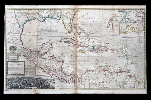
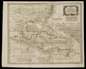
A MAP of the/ WEST-INDIES/ or the Islands of AMERICA/ in the NORTH SEA; with y.e adjacent/ Countries; explaining what belongs to SPAIN,/ ENGLAND, FRANCE, HOLLAND &c.
Date1740-1745 (originally published 1715)
Cartographer
Herman Moll (1654?-1732)
OriginEngland, London
MediumBlack and white line engraving with period hand color on laid paper
DimensionsOH: 25" x OW: 40 5/8"; Plate H: 23 1/2" x W: 40 1/8"
Credit LineMuseum Purchase
Object number1988-408
DescriptionThe lower left title cartouche reads: "A MAP of the/ WEST-INDIES/ or the Islands of AMERICA/ in the NORTH SEA; with y.e adjacent/ Countries; explaning what belongs to SPAIn,/ ENGLAND, FRANCE, HOLLAND &c./ also y.e TRADE WINDS, and y.e several Tracts/ made by y.e Galeons and Flota from place to place./ According to y.e Newest and most Exact Observations/ By Herman Moll Geographer."The cartouche above the title cartouche reads: "TO/ WIL. PATERSON/ Esq; This Map of the/ WEST-INDIES &c. is/ most Humbly Dedicated/ By Her. Moll Geographer."


After 1735; originally published 1715


1800-1820