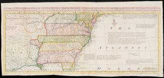
A General Map of the Middle British Colonies
Date1755
Compiler
Lewis Evans (ca. 1700-1756)
Engraver
James Turner (1722-1759)
OriginEngland, London
MediumLine engraving on laid paper with hand coloring; iron gall ink.
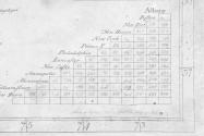
DimensionsOverall: 20 1/2 × 26 3/4in. (52.1 × 67.9cm)
Credit LineGift of Mike and Carolyn McNamara
Object number2022-153
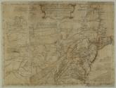
DescriptionThe upper center cartouche reads: "A general MAP of the/ MIDDLE BRITISH COLONIES, in AMERICA;/ Viz VIRGINIA, MARILAND, DELAWARE, PENSILVANIA,/ NEW-JERSEY, NEW-YORK, CONNECTICUT, and RHODE ISLAND:/ Of AQUANISHUONIGY, the Country of the Confederate Indians;/ Comprehending AQUANISHUONIGY proper, their Place of Residence,/ OHIO and TIIUXSOXRUNTIE their Deer-Hunting Countries,/ COUXSAXRAGE and SKANIADARADE, their Beaver-Hunting Countries;/ of the LAKES ERIE, ONTARIO and CHAMPLAIN,/ And of Part of NEW-FRANCE:/ Wherein is also shewn the antient and present SEATS of the Indian Nations."The upper left cartouche reads: "Permit me, Sir, to pay You this Tribute of Gratitutde,/ for the great Assistance You have given me in this Map; and to/ assure the Public, that it has past the Examination of a Gentleman,/ whom I esteem the best Judge of it in America:/ Your most obedient,/ and most humble Servant,/ LEvans." [Lacks dedication to Thomas Pownall]
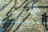
Below the distane table, lower right corner: “Lewis Evans Esq.r, Sawkill[?] May 6, 1755” [In manuscript]
Label TextThis is the earliest known printing of Lewis Evans's "General Map of the Middle British Colonies, in America.
In 1755, General Edward Braddock, accompanied by Lieutenant Colonel George Washington, led an expedition to capture Fort Duquesne from the French. The construction of the French fort in 1754 at the fork of the Ohio, Allegheny, and Monongahela Rivers, threatened British expansion and triggered the French and Indian War. Obtaining an accurate map of the region was critical to the success of Braddock’s mission to secure the strategic location for the British.
Benjamin Franklin reached out to his close friend, Philadelphia mapmaker Lewis Evans, who provided an early copy of his newest map of the middle colonies that incorporated the most recent surveys. Franklin included it among the supplies sent to Braddock’s troops at Fort Cumberland. When the map arrived there on May 21, 1755, it had additional information handwritten by Evans that may have been provided to him by Franklin.
Long thought to have been lost or taken by the French at the time of Braddock’s defeat and death at the Battle of Monongahela, this map, when examined under UV light, bears the critical date of May 6, 1755, and contains manuscript notations specific to the route of the expedition. These manuscript additions made to Evans’s draft map leave no doubt that this is the map that accompanied General Edward Braddock on his expedition to the Ohio.


June 14, 1782