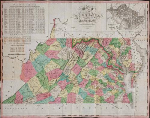
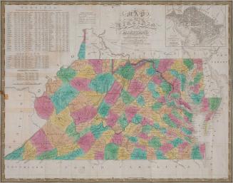
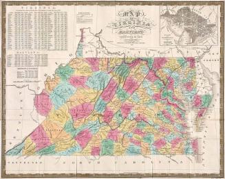
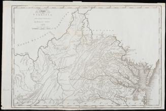
Map of Virginia and Maryland Constructed from the Latest Authorities 1824
Date1824/1826?
Publisher
Anthony Finley
(1790-1840)
Engraver
James Hamilton Young
(fl. 1817 - 1866)
Compiler
David H. Vance
MediumBlack and white line engraving with period color; Case: stamped brown leather, green wove paper, boards, adhesive, gold gilt
DimensionsFolded (case): H: 6" x W: 3 3/4"; Unfolded (Map): OH: 17 1/4" x OW: 21"
Credit LineMuseum Purchase
Object number2017-173
DescriptionCase:Front reads: "VIRGINIA/ & MARYLAND"
Map:
Main title reads: "MAP/ OF/ VIRGINIA/ AND/ MARYLAND/ Constructed from the Latest/ AUTHORITIES./ 1824."
Label TextPocket maps gained popularity in the second decade of the nineteenth-century. Instead of being dissected, mounted on linen, folded and placed in separate map cases, these pocket maps were printed on thin paper and attached to boards into their own integral cardboard covers. Published by Anthony Finley, this pocket map was originally drawn by David H. Vance (D.H. Vance) and engraved by James Hamilton Young (J.H. Young).The data tables in the upper left inset are from the 1820 census. The inset in the upper right represents Washington, DC and Georgetown.
This copy originally published in William C. Wooldridge, "Mapping Virginia: From the Age of Exploration to the Civil War" (Charlottesville: University of Virginia Press, 2012), #195, pp. 212-216.


1826
1820/1823