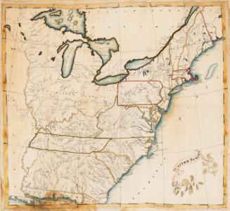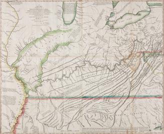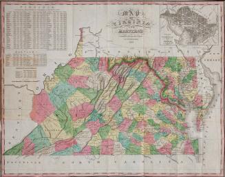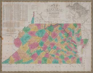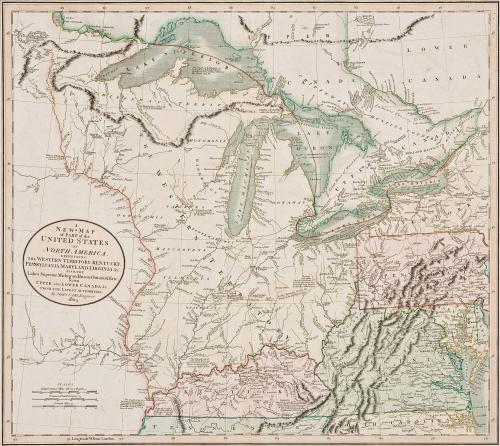
A New Map of Part of the United States of North America, Exhibiting The Western Territory; Kentucky, Pennsylvania, Maryland, Virginia &c. Also, the Lakes Superior, Michigan, Huron, Ontario & Erie; With Upper and Lower Canada &c. From the Latest Authorities. By John Cary; Engraver 1805
Date1808
Maker
John Cary Sr.
(1755 - 1835)
OriginEngland, London
MediumBlack and white line engraving with period color
DimensionsOH: 22 1/8" x OW: 26 1/2"
Credit LineMuseum Purchase
Object number2017-120
DescriptionCartouche reads: "A/ NEW MAP/ of PART of the/ UNITED STATES/ of/ NORTH AMERICA,/ EXHIBITING/ THE WESTERN TERRITORY, KENTUCKY,/ PENNSYLVANIA, MARYLAND, VIRGINIA &c./ ALSO, THE/ Lakes Superior, Michigan, Huron, Ontario & Erie;/ WITH/ UPPER AND LOWER CANADA &c./ FROM THE LATEST AUTHORITIES./ BY JOHN CARY, Engraver./ 1805."Lower margin reads: "London, Published by J. Cary, Engraver & Map seller N.o 181 Strand, June 1, 1805."
Label TextAfter the Revolution, Virginia offered to cede lands northwest of the Ohio River to the newly formed Federal Governent. This area became known as the Northwest Territory which was organized in 1787 by the Northwest Ordinance. Despite the adoption of Ohio's statehood in 1803, this map depicts that region as The Western Territory. This map was originally published in 1805, but this particular copy was originally included in "Cary's New Universal Atlas" (1808).
This copy is published in William C. Wooldridge, “Mapping Virginia: From the Age of Exploration to the Civil War” (Charlottesville: University of Virginia Press, 2012), #137, pp. 145-146.