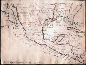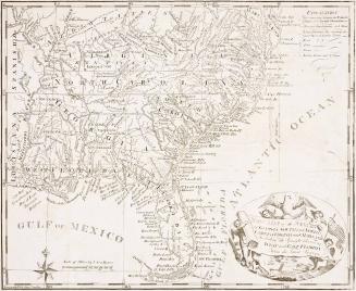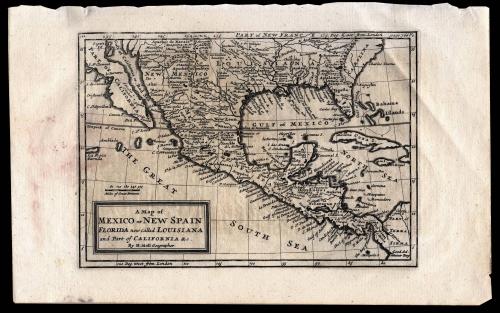
A Map of Mexico or New Spain Florida now called Louisiana and Part of California & c.
Date1708
Maker
Herman Moll (1654?-1732)
OriginEngland, London
MediumInk on laid paper
DimensionsOverall: 8 3/4 x 14in. (Plate H: 7" Plate W: 10")
Credit LineMuseum Purchase
Object number2013-2
DescriptionA Map of Mexico or New Spain, Florida now called Louisiana and Part of California & c.Label TextIn the eighteenth century the cartography of Spain's possessions in America expanded rapidly and numerous European cartographers issued maps inteded to satisfy intense curiosity concerning the vast regions that Spain attempted to keep secret.
Explorers and missionairies from Spain, France, and the Holy Roman empire all contributed to the knowlege of the region.
It is debateable whether or not Moll had knowledge of Father Eusebio Francisco Kino's missions in the Pimeria Alta and Baja regions. The way that the map is crop leaves it a mystery as to whether Moll believed California to be an island or penninsula; although he is quoted as having said that California is without a doubt an island. Kino had documented the route to California during a trip there between 1698 and 1701 but his map was not published until 1708, although many had heard about his findings soon after his return in 1701.
Guillaume Delisle published a very similar map, "Carte du Mexique et de la Floride des Terres Angloises et des Isles Antilles du cours et des environs de la Riviere de Mississipi," in 1703 which uses Kino's information (mission and place names) but uses the same cropping technique as Moll where California is left ambiguous.