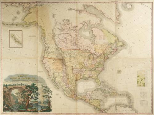
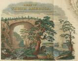
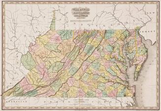
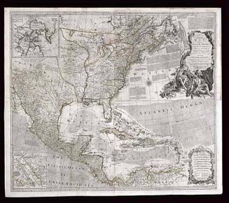
A MAP OF NORTH AMERICA,/ CONSTRUCTED ACCORDING TO THE LATEST INFORMATION:
Date1822
Cartographer
Henry Schenck Tanner (1786-1858)
Engraver
Henry Schenck Tanner (1786-1858)
Publisher
Henry Schenck Tanner (1786-1858)
Printer
William Duffee
MediumLine engraving on laid paper with hand color
DimensionsFramed: 45 3/4 × 59 1/2in.
Credit LineMuseum Purchase
Object number1997-5
DescriptionThe lower left cartouche reads: "A MAP OF NORTH AMERICA,/ CONSTRUCTED ACCORDING TO THE LATEST INFORMATION:/ by H.S. TANNER."Text below the cartouche reads: "Natural Bridge in Virginia./ Falls of Niagara."
The lower margin reads: "Entered according to Act of Congress the 27.th day of March 1822, by H.S. Tanner of the State of Pennsylvania/ Printed by W.m Duffee./ Engraved & Published by H.S. Tanner, Philadelphia, 1822."
Label TextThomas Jefferson and James Madison, among others, believed that the success of the new nation was tied to the exploration and cultivation of the frontier. Following the Purchase of Louisiana in 1803, Jefferson commissioned Meriwether Lewis and William Clark to map the newly acquired territory and to find a route across the continent. Their expedition opened the door for new explorations and helped to establish a United States presence in the West. Henry Tanner incorporated information from discoveries made by Lewis and Clark (1804-06), Zebulon Pike (1806) and Stephen H. Long (1819-20) to create the most significant map of the American West produced during the first decades of the nineteenth century.
Americans began to regard natural wonders as symbols of their national pride. The cartouche on Tanner's maps combined images of Niagara Falls and Natural Bridge along with other symbolic forms of American fauna such as a rattlesnake, a beaver, and an eagle.
1820/1823
1729-1730


1732