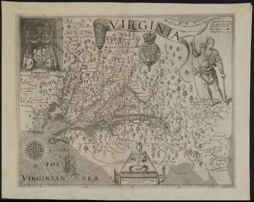
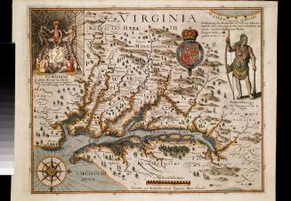
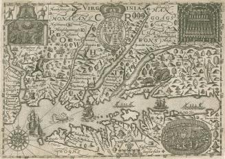
VIRGINIA
Date1612
Cartographer
Captain John Smith (1580-1631)
Engraver
William Hole (fl. 1600-1646)
OriginEngland, London
MediumLine engraving on laid paper
DimensionsOverall: 15 × 18 1/2in. (38.1 × 47cm)
Framed: 22 1/2 × 26 5/8in.
Credit LineGift of Mr. and Mrs. Richard F. Barry, III, Mr. and Mrs. Macon F. Brock, Mr. and Mrs. David R. Goode, Mr. and Mrs. Conrad M. Hall, Mr. and Mrs. Thomas G. Johnson, Jr., Mr. and Mrs. Charles W. Moorman, IV, and Mr. and Mrs. Richard D. Roberts
Object number2017-197
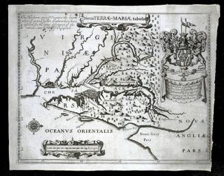
DescriptionTitle in banner: VIRGINIALabel TextOne of the most important printed maps ever produced, Captain John Smith's representation of Virginia based on his explorations of the Chesapeake Bay in 1607 and 1608 is a key object in Colonial Williamsburg's collection. The accuracy and detail far surpassed any other depiction of North America at the time it was made. Smith's Virginia served as the prototype for maps of the area for over fifty years.
In December 1606, the London Company sent three vessels to America under the command of Captain Christopher Newport, who was instructed to find a safe port at the entrance of a navigable river in Virginia, "that which bendeth most toward the North-west for that way you shall soonest find the other sea." 1 Finding a passage to Asia and to exploring the mineral resources of America was implicit in the company's mission. The ships arrived at Jamestown in May 1607. Shortly afterward, a party of just over twenty men, including Smith and Robert Tindall, under the leadership of Captain Newport set out to explore the James River as far as the falls, the present site of Richmond.2
Upon their return, the men found that natives had attacked the Jamestown settlement during their absence, killing one colonist and wounding seventeen. The colonists immediately began to fortify Jamestown and obtain rations for the starving Englishmen. By the end of June, Captain Newport left for England to secure provisions and recruit new settlers. After he departed, Smith assumed the role of supply officer, bartering with neighboring Indians for food. While exploring the mouth of the Chickahominy River in December 1607, Indians captured Smith and held him prisoner for several weeks. Eventually, Smith negotiated his release with their powerful chief Powhatan.
In June 1608, Smith and fourteen men set out in an open boat to explore the Chesapeake. They covered about three thousand miles between June and September, sailing to the northern tip of the Chesapeake Bay, up the Potomac River as far as present-day Georgetown, and investigating the Patuxent, Susquehanna, Rappahannock, and Piankatank Rivers before returning to Jamestown.
All along the way, local Indians willing to trade food for trinkets approached them. Smith took advantage of these encounters to ask the Native Americans about the geography. He included many features they relayed on the map beyond the Maltese crosses, explaining, "As far as you see the little Crosses on riuers, mountaines, or other places, haue beene discovered; the rest was had by information of the Savages, and are set downe according to their instructions."3 The contributions of Native Americans to Smith's understanding of the geography of the region played a significant role in the overall accuracy of his work. Firsthand knowledge of the Chesapeake Indians and the locations of their villages make the map invaluable because Smith named ten tribes and located one hundred sixty-six of their villages.
After he was wounded by an accidental gunpowder explosion, Captain Smith returned to England in September 1609. The next year, he began work on A Map of Virginia, With a Description of the Country, published in Oxford in 1612 by Joseph Barnes. This map, beautifully engraved by one of England's finest engravers, William Hole, accompanied Smith's written description. Cartographic historians have questioned whether Smith actually drafted the manuscript map used as the source for the printed version.4 He may have consulted sketches by Robert Tindall or Nathaniel Powell. Regardless of who the actual draftsman was, Smith was primarily responsible for charting the vast area. The map was included in two later publications, John Smith's The Generall Historie of Virginia, New-England, and the Summer Isles, 1624, and Samuel Purchas, Purchas His Pilgrimes, 1625.
Three distinctive geographical features on Smith's map influenced subsequent works: the eastward turn of the head of the Chesapeake Bay, the Delmarva Peninsula, which extends too far to the east, thereby considerably enlarging the area, and the pronounced "Z" shape of the Potomac River. The eastward distortion of the Delmarva Peninsula was probably due to the fact that Smith never explored the Atlantic coast of the Eastern Shore.
Historians have often suggested that the Susquehanna Indian illustrated on Smith's map was borrowed from Theodore de Bry's A weroan or great Lorde of Virginia. While similarities exist, it is clear that Smith's Indian was based on his written description. The native depicted by de Bry was an Algonquian Indian from North Carolina. Bare-chested and wearing a necklace of pearls or copper beads, the subject's long hair is bound up at the ends in a knot under the ears with three feathers attached at the forehead and above each ear.
The Susquehanna Indian Smith illustrated wears his hair loosely rather than knotted under the ears and adorned with feathers as de Bry's did. Of the Susquehannas' clothing, Smith wrote:
Their attire is the skinnes of Beares and Woolues, some haue Cassacks made of Beares heades and skinnes that a mans necke goes through the skinnes neck, and the eares of the beare fastned to his shoulders behind, the nose and teeth hanging downe his breast, and at the end of the nose hung a Beares Pawe: the halfe sleeues comming to the elbowes were the neckes of Beares and the armes through the mouth, with pawes hanging at their noses. One had the head of a Woolfe hanging in a chaine for a Iewell [jewel].5
he object pictured in the Susquehanna's left hand has been identified as a hatchet or cudgel, but close examination reveals that it could not be a hatchet because the end does not have a straight, sharp surface of the type necessary for chopping. Although the implement could be some form of club, it very closely resembles Smith's description of a Susquehanna tobacco pipe as "3 quarters of a yard long, prettily carued [prettily carved] with a Bird a Beare, a Deare, or some such devise at the great end, sufficient to beat out the braines of a man."6
The wolf's-head pendant worn by Smith's Indian, which was not depicted in any of de Bry's illustrations, was a type apparently worn by Leni-Lenape or Susquehanna Indians. The earliest known surviving example of one of these pendants, made from the jaws of a mature eastern wolf, is in a collection at Skokloster Castle, Sweden, one of a number of surviving artifacts from the seventeenth-century collection of Count Carl Gustaf Wrangel, objects presumably presented as ceremonial gifts to Johan Printz, colonial governor of New Sweden from 1642 to 1653.7 Herbert C. Kraft, of the Seton Hall University Museum, who examined the wolf's head in the Skokloster Castle collection, described the object as follows:
"[It was] constructed around portions of the maxilla sawed or broken away from the nasal and cranial portions of a wolf's skull, and a mandible from which parts of the ascending rami have been removed. Beginning with these tooth-bearing elements, seemingly with gum tissue attached, the artisan constructed an artificial head from a buckskin covering stuffed with deer hair. The tooth-bearing elements were meticulously fashioned into the formed "head" by sewing the buckskin "lips" to the gum tissues in a way that left the teeth exposed. An indigo-dyed woolen trade cloth tongue was included for realism."8
1. Instructions by way of advice, for the intended Voyage to Virginia, Edward Arber, ed., Capt. John Smith Works 1608-1631 (London, 1895), p. xxxiv.
2. Tindall produced a draft map during this expedition that Capt. Newport took back to London.
3. "Map of Virginia," by Captain John Smith, Arber, ed., Smith Works, p. 55.
4. For a thorough discussion of the arguments for and against attributing the map manuscript to Smith, see Verner, "Smith's Virginia," pp. 139-141.
5. Arber, ed., Smith Works, p. 54.
6. Ibid.
8. Richard S. Dunn, "Religion, Politics, and Economics: Pennsylvania in the Atlantic World, 1680-1755," in Jack L. Lindsey, Worldly Goods: The Arts of Early Pennsylvania, 1680-1758 (Philadelphia, Pa., 1999), pp. 18, 228.
9. Herbert C. Kraft, "Lenape and/or Susquehannock Treasures," Bulletin of the Archaeological Society of New Jersey, L (1955), p. 6. I want to thank Richard Guthrie for providing this reference and many others.
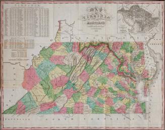
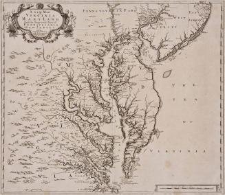
This copy is published in William C. Wooldridge, "Mapping Virginia: From the Age of Exploration to the Civil War" (Charlottesville: University of Virginia Press, 2012), Map 26, pp. 32-34.
1627
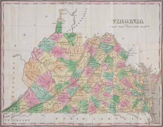
1826
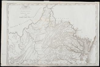
1636