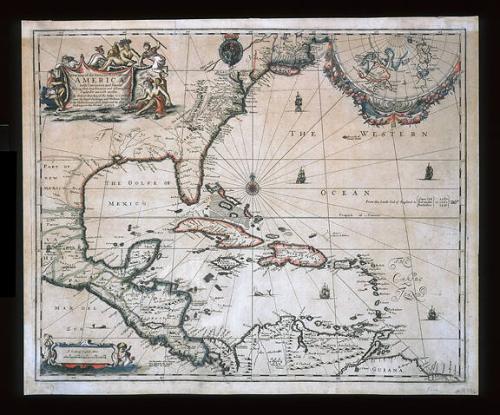
A New Map of the ENGLISH PLANTATIONS in/ AMERICA./ both Continent and Ilands,/ Shewing their true Situation and distance, from/ England or one with another
Date1673
Cartographer
Robert Morden (d. 1703)
Cartographer
William Berry
(fl. 1669 - 1708)
OriginEngland, London
MediumLine engraving on laid paper with hand color
DimensionsOverall: 17 7/16 × 21 1/8in. (44.3 × 53.7cm)
Framed: 26 1/8 × 29 3/8 × 7/8in.
Credit LineMuseum Purchase
Object number2000-17
DescriptionThe upper left cartouche reads: "A New Map of the ENGLISH PLANTATIONS in/ AMERICA./ both Continent and Ilands,/ Shewing their true Situation and distance, from/ England or one with another,/ By Robert Morden, at the Atlas. in Cornhill/ nere the Royal Exchange, and William Berry/ at the Atlas. in Corhill/ nere the Royal Exchange, and William Berry/ at the Globe. between York House and the New/ Exchange in the Strand, LONDON."Label TextWhile Robert Morden and William Berry's A New Map of the English Plantations in America illustrates no territory identified as being inhabited by Natives, the cartouche is decorated solely with depictions of Indians. Several are pictured holding a banner containing the title of the map. Depicting them in this manner subtly suggests that they support or uphold the claim suggested by the title contained within the banner - that the geography illustrated belonged to England.
The majority of cartouches on seventeenth- and early eighteenth-century maps of America contain decorative images of the Native population. By the middle of the eighteenth century, most of the ornamentation used depicted the slave populations.


December 21, 1785

ca. 1745